Hey I'm new to the site and I was hoping someone could help.
My parents just bought a lake house by burnside island. My mom was really wanting a huge Map of the lake to put on the family room wall. I have been looking around and I can't really find anything. I contacted FatHead and they can make it if I have the file but I'm having troubles finding that.
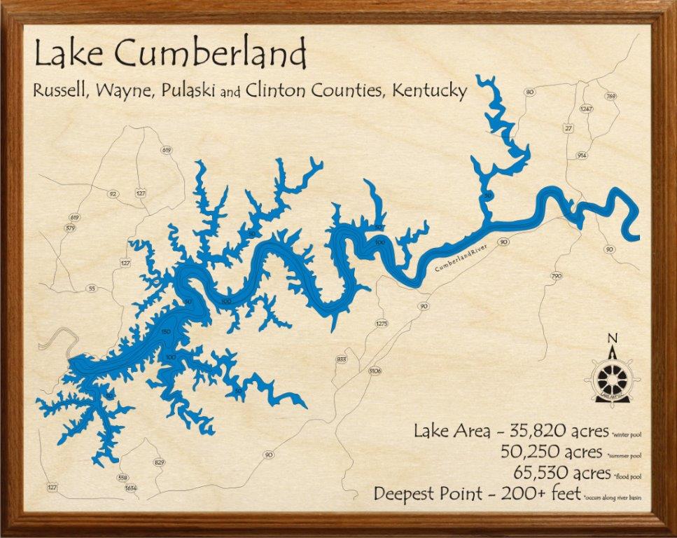
Below is the best map I can find. I like how it has all the mileage navigation markers and so on, apposed to a simple areal map. http://www.statedock.com/2012map.pdf
The problem is it stops right past Conley. Maybe being at the other end it would be fine but since we're at the top end I'd like have it. Anyone have a complete map like this????
Thanks in advance,
Jason
( tagging this post with Distance Mileage chart graph EH)
Lake cumberland map
Moderators: E_, LC addict, FasterThanYou, crwky
-
Chaparral_256ssi
- I posted something! WooHoo!
- Posts: 2
- Joined: Thu Mar 13, 2014 5:35 pm
-
E_

- Site Admin
- Posts: 14802
- Joined: Fri Oct 24, 2008 10:26 pm
- Marina/Ramp: Currently mostly out of Jamestown but spend a lot of time at the other Marinas.
Pre2012-Conley Bottom Mostly, Waitsboro, Alligator I&II ramps, Leesford, Pulaski County Park (when it has water), Grider, State Dock (via boat), and Jamestown are a few places you might find me. - Location: Kentucky (Lake Cumberland)
- Contact:
Re: Lake cumberland map
Welcome Chaparral! On this site I have a HUGE lake Cumberland map that I have printed and given to a few friends and have hanging in the office at my house. It is not super pretty but is more lake and road focused as it is built off the county highway maps merged together and colored in...
http://www.lakecumberlandboaters.com/fi ... erlandMap/
You can get this one on our cafepress page as a poster, clock, shirt, or blanket as seen here:
http://www.cafepress.com/+lake_cumberla ... ,848710252
Here is a neat Satellite print I found - http://www.zazzle.com/lake_cumberland_k ... 1762118924
Here is another nice one http://www.yournewboat.com/BoatingTips/ ... erland.jpg
from http://www.yournewboat.com/BoatingTips/ ... Guide.html
And another one I've seen before and think is really nice
http://www.zazzle.com/lake_cumberland_k ... 4387895640
Buy American, the job you save just might be your own.
-
E_
- Site Admin
- Posts: 14802
- Joined: Fri Oct 24, 2008 10:26 pm
- Marina/Ramp: Currently mostly out of Jamestown but spend a lot of time at the other Marinas.
Pre2012-Conley Bottom Mostly, Waitsboro, Alligator I&II ramps, Leesford, Pulaski County Park (when it has water), Grider, State Dock (via boat), and Jamestown are a few places you might find me. - Location: Kentucky (Lake Cumberland)
- Contact:
Re: Lake cumberland map
Here is more LakeCumberlandBoaters.com gear at http://www.cafepress.com/lakecumberlandboatersgear
On the left is a link to the LakeCumberlandHighwayMap collection if you want to look at more options for it.
Some of the other members might have some other good map links.
On the left is a link to the LakeCumberlandHighwayMap collection if you want to look at more options for it.
Some of the other members might have some other good map links.
Buy American, the job you save just might be your own.
-
Chaparral_256ssi
- I posted something! WooHoo!
- Posts: 2
- Joined: Thu Mar 13, 2014 5:35 pm
Re: Lake cumberland map
Great thanks! I'll look into these this morning.
-
E_
- Site Admin
- Posts: 14802
- Joined: Fri Oct 24, 2008 10:26 pm
- Marina/Ramp: Currently mostly out of Jamestown but spend a lot of time at the other Marinas.
Pre2012-Conley Bottom Mostly, Waitsboro, Alligator I&II ramps, Leesford, Pulaski County Park (when it has water), Grider, State Dock (via boat), and Jamestown are a few places you might find me. - Location: Kentucky (Lake Cumberland)
- Contact:
Re: Lake cumberland map
Heres another version of the old map I made from highway maps and combined them. This one only has the lake colored.
- Attachments
Buy American, the job you save just might be your own.
-
E_
- Site Admin
- Posts: 14802
- Joined: Fri Oct 24, 2008 10:26 pm
- Marina/Ramp: Currently mostly out of Jamestown but spend a lot of time at the other Marinas.
Pre2012-Conley Bottom Mostly, Waitsboro, Alligator I&II ramps, Leesford, Pulaski County Park (when it has water), Grider, State Dock (via boat), and Jamestown are a few places you might find me. - Location: Kentucky (Lake Cumberland)
- Contact:
Re: Lake cumberland map
Here is a state dock map that someone shared on our FB page. Has Lon/Lat coordinates blocked out. And mileages as well as VHF channels for Marinas etc.
(Edited) lol just realized this is the same one Chaparral posted long ago. PS my giant old map is still located at http://www.lakecumberlandboaters.com/fi ... erlandMap/
State Dock map has the "Emergency" channels as 16 and 24. You should all be aware that channel 24 is State Dock's personal channel for their rental boats to communicate "emergencies" regarding their rentals back to them and not for general emergencies on the lake for which you need real assistance for life threatening issues. That channel is and will always be channel 16 world wide, or to dial 911 locally.
(Edited) lol just realized this is the same one Chaparral posted long ago. PS my giant old map is still located at http://www.lakecumberlandboaters.com/fi ... erlandMap/
Buy American, the job you save just might be your own.